Transit Apps : Benefit or Crutch?
We’re all caught up in transit app fever. At Nextransit we’re working on apps that seek to improve our urban environment, but what’s the best way to do that?  We’ve released 2 apps, Nexmap and Nextime, and they both address shortcomings in our current transit systems.  While these are absolutely a necessity (have you ever tried to figure out a bus map? how often is your bus on time—in the middle of the winter?), what is the long term effect?
Transit isn’t just for commuting
Transit-oriented cities love to brag about the percentage of workers that take transit to work, rather than drive. In fact, here in Cambridge, we love to brag about how fewer than 50% of Cantabrigians commute by car. While this statistic is already a bit skewed as 1/3 of our population is made up of students, the true key word to notice in there is commute. You’ll frequently see US cities talking about how many people commute via car vs. transit vs. bike.
While this is absolutely a great thing, what’s really important isn’t just how many people don’t want to hassle with traffic en route to work, but how many people feel that they can access the things they need in daily life via means other than car ownership. For example, of the non-student population of Cambridge, there are about 1.4 cars per household. When comparing to the average cars per household in European cities, inner cities have ~ 0.5 cars per household, while exurbs have just shy of 1.4. So one of the best cities in the US for commuting by means other than car, still comes in with over 3 times the car ownership of a European city, tying with the exurbs.
This isn’t to say that Cambridge should be compared to inner London or Amsterdam, but it’s important to look at the differences. One of the key distinctions is precisely how accessible basic needs are. It may seem reasonable to walk 15 minutes to catch a train which takes 20 minutes to get to work, when you’re doing it as part of a commute. But if you have to walk 15 minutes to catch a train every time you want to pick up chips and salsa for a gathering of friends, it’s a very different story.
Is Transit Just an Overlay?
We’re all familiar with road maps. Â They generally take a somewhat 1:1 mapping to a satellite image, removing obstacles like parked cars, trees, and buildings. Â It lets us cleanly see where roads go and how to get from one place to another. Â Online mapping services, from Mapquest to Google Maps, use a scaling model: when you’re zoomed out, you only see major roads (like highways). Â As you zoom in, major throughways appear, and finally small alleys.
Transit maps, in contrast, have been painstakingly designed over the years to be simple and legible, promoting comprehension and clarity over physical accuracy. Â This provides a wonderful way to navigate a transit system. Â Google Maps recently added their own transit overlays, but are forced to map them to the real-world accurate locations, not the representations.
WalkScore Transit Time
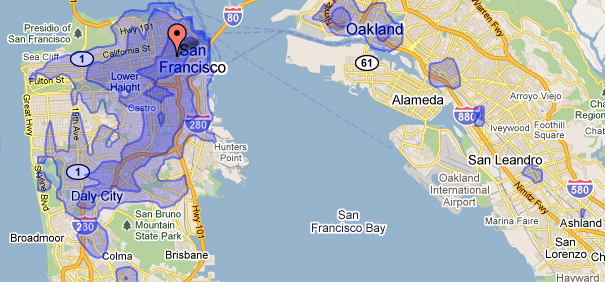
From the folks who brought you the infamous Walk Score for your neighborhood comes the Transit Time Map. This clever tool lets you calculate where you can travel on transit from any location, within certain amounts of time (15, 30, and 45 minutes). It’s not something you want to use while planning a trip, but rather it focuses on the mobility offered from where you are. This is a great way to see how easily you can access areas based on where you might want to live, and the effects of living a few minutes closer to better transit. Â It’s only available in a few select cities right now, but it’s an invaluable tool to figuring out how easy you can do things you care about: visit friends, get to work, go out, etc.
On Rails & Tires
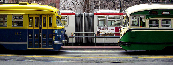
An often discussed theme in transit planning is the various pros and cons of trains and buses. Â The basic assumption goes like this: Rail is preferred, but it costs more. Buses aren’t as nice, but are much cheaper. Jarrett Walker at HumanTransit.org wrote a somewhat provocative article in 2009, trying to capture what the aversion to buses are when compared to streetcars, despite many advantages of buses:
Streetcars do attract more ridership than the buses they replace, though it’s not always clear why. Â There’s an urgent need for more research on how much of the ridership benefits of a streetcar are truly results of intrinsic benefits of the streetcar (such as the ride quality, the legibility provided by tracks in the street, etc) as opposed to results of other improvements introduced at the same time (including speed and reliability improvements, better public information, off-board fare collection, and possible differences in operations culture).
[If] you want a streetcar because it’s intrinsically faster and more reliable than a bus — well, that’s just not true.
At Nextransit, we firmly believe that rail simply offers a better user experience. Â In theory, or at least on paper, one could develop a bus line that follows the exact same patterns as rail: multiple door boarding, covered platforms, dedicated busways, electrified buses. Â Yet there are some examples of this, like the Silver Line in Boston, and they still do not have the same “feel” as rail.
Changing the face of transit
So here we are, 2011, fully into the second decade of the “new” millennium. We have advanced technologically from a time when a basic computer took up a full room to now having miniature, always-connected computers in our pockets. The world has been brought closer with remote communication, but we’re still relying on old-world technology to transport us around, to communicate in person.
Millions of tanks of liquid fuel drive around in huge metallic shells with wheels, designed to transport humans faster than what we can do on foot. In the process, we’ve killed 50 million people through car accidents (with over 1 million car-related fatalities per year), led to the rise of suburbs and exurbs (and big box stores, huge parking lots…), released over 80 billion metric tons of CO2 into the atmosphere through vehicle emissions alone, paved over 70% of our urban environments (60% of which is for parking alone), and led to one of the most anti-social external environments we’ve ever seen—ironically, in urban centers. All while creating a human-hostile environment outside of our homes, places of work, and commercial locations.
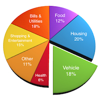
 Yet the reaction is clear. More and more people don’t want the hassle and cost of car ownership, maintenance, and storage. They want to be able to walk to get good great food, visit friends, and have fun. The 1950s model—where a car was equal to freedom—is dying, as commute times have skyrocketed, gridlock is the norm, and we feel trapped sitting in our cars. (The average driving speed through New York City has actually decreased since the horse.) To many, a car is accepted as a given expense, but think of what can be gained without having to hassle one. The average American spends almost 20% of their income on transportation-related costs (just shy of $9,000 / year), almost as much as the average amount spent on shelter, and the highest average transportation-related costs in the world. Meanwhile 75% of Americans live in urban environments where the average cost of unlimited public transportation rides is $650 / year, an order of magnitude less than car ownership (around 1.2% of average annual income). We could put that extra $8,350 into buying better food, higher quality products, or extra savings.
While the reaction is clear, the problem is complex. Many American transit systems simply aren’t up to the task, with problems ranging from perpetual underfunding to lack of vision. Urban sprawl and lack of density have created an environment where traditional subways and light rail can’t serve the daily needs of a large population, while distances are too far to walk and cars rule the roads, making biking difficult and sometimes dangerous. Car sharing is beginning to take hold which, along with bike sharing, seeks to address the needs of a modern generation: mobility without all of the hassles of individual ownership.
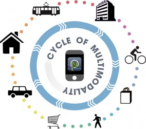
 At Nextransit, we believe these problems demand better service, more choices, and we should all demand a better quality of life. These issues can be addressed through social change, better infrastructure investment, and an expanse of multimodal transportation options. But there needs to be a strong vision in guiding how all of these components interact, and how to guide users between all options effectively. We see the solution to these issues in advanced integrative technology and personal mobility: creating mobile navigation apps to guide people to where they’re going, developing better live routing algorithms to serve the needs of a mobile population, and working with cities to improve the urban “user experience” across the board. No single transportation model will meet everyone’s needs, but through a new network of multimodal services, we can deliver a central user experience across all modes for each person at any given moment. We believe the software design and user experience approach to transit and urban mobility is the best way to innovate in radical new ways in the urban space. We’re interested in helping navigate this space with technology: helping you move through a city as efficiently as possible, and building for the future, giving each of us a sense of place, and a sense of pride for where we live.
So while we can’t solve all of these problems overnight, Nextransit aims to move, one step at a time, towards a goal of interconnected people, moving through a place, interacting, where we live.


